
2024|25
Product Design MA
Royal College of Art
Awards & Publications
Service: Electronic Design | UI Design |
UX Research | CAD | PCB Manufacturing
Move smarter with wati, the wearable designed to navigate urban heat. wati keeps you cool, hydrated, and always informed of live weather and temperature changes on the go.
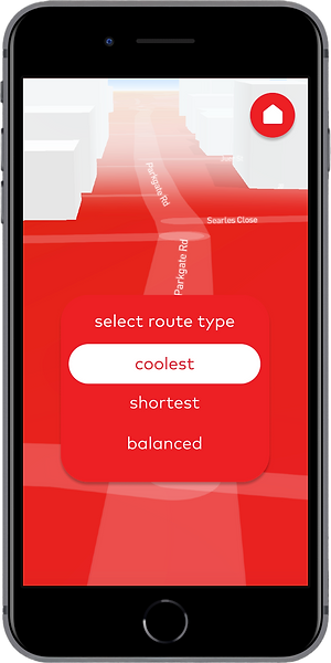
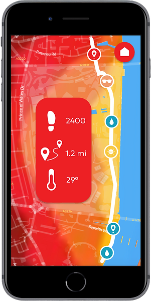
Whether you're walking, running, or commuting, wati tracks live outdoor temperatures, monitors your steps, and guides you through the coolest routes via the paired mobile app.
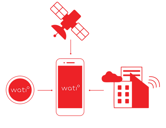
By choosing wati, you join a global crowdsourcing community that refines "cool-route" algorithms and informs future city planning. The app uniquely combines ground-level user data with satellite-based thermal imaging, creating a powerful new layer of climate insight.

WATI addresses the gap in localized heat awareness by providing the ground-level temperature precision that current weather apps and fitness wearables lack.
It moves the world out of a WAIT state on climate change by turning urban navigation into a tool for real-time thermal insight.
Hyper-local Tracking: Measures real-time ambient temperature at ground pedestrian level.
Data Visualisation: Communicates thermal and health metrics through a custom designed UI.
Predictive Analytics: Delivers real-time heat alerts and actionable environmental and health data.
Hybrid Mapping: Merges EO satellite thermal imaging with user-sourced ground data for maximum precision.
Smart Navigation: Identifies ventilated, shaded, and cool-route alternatives via the paired app.
Urban Impact: Crowdsources heat-mapping data to assist city planners in building resilient infrastructure.

01
outdoor athletes and runners -
ideal user group for testing
02
elderly people - heat related mortality increases by 85%
03
young children (0 to 4) and pregnant women - struggle with thermoregulation
04
individuals with chronic health conditions - cardiovascular, kidney, respiratory problems
05
transportation and construction workers - bus drivers, train drivers, bikers, delivery drivers


Hardware
Wearability
Mobile UI
Data & Community
Advanced Sensor Technology:
MEMS Thermal | Gyroscope
Multiple-Attachment System: Clip | Watch | Armband
Route Options:
Shortest | Balanced | Coolest
Crowdsourced Heat Mapping:
Dynamic | infrastructure | UHI
High-Resolution Touchscreen
10-Hour Battery Life
Personalised AI Urban Companion
Step & Mileage Analytics
USB-C Rechargeable
Touchscreen High-Contrast UI
UV | Shade | Hydration Alerts
Community Achievement Feed


The System
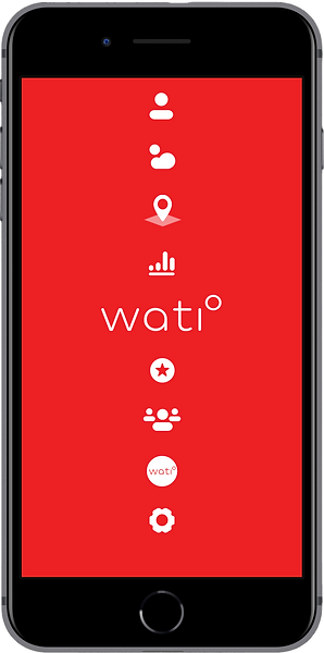
WATI Mobile App UI Design


Heat Maps & Thermal Satellite Images from Data Providers

London, United Kingdom, Urban Heat Maps provided by meteoblue


Riyadh, Saudi Arabia, LST Fusion product provided by constellr
Darwin, Australia, Thermal Infrared Imagery - © [2024] SatVu

